We made an unusually long (for us) trip from the northern Chesapeake Bay to Sandy Hook, NJ in a 30 hour run over July 25 / 26th. The weather was cooperating and we decided to take advantage of it to make the trip north. That put NYC within sight, but we still had to time our transit through to ensure we were riding the favorable currents through the East River, and, particularly, the appropriately named Hell Gate. We are now in Long Island sound, at Port Washington, with all of that travel behind us. After sitting for so long on shore, it’s hard to believe we’ve traveled so far in such a short time.
Hampton to Mid-Bay
We made a quick trip up the first 150 miles of the Chesapeake Bay. We were making good time our first day out, so we bypassed Fishing Bay (near Deltaville, VA) for an anchorage on the Great Wicomico, Sandy Point, near Reedville. This was probably the hottest, most uncomfortable night we had over the past 2 weeks. The record high heat and humidity told us that violent thunderstorms were sure to come. We just managed to dodge one as we entered the anchorage that afternoon. With this in mind, we left early the next morning for Solomons, MD, wanting to be get in early enough to get fuel and water and secure a mooring before the storms rolled through.
And storm it did.
It was a mercilessly hot day – the classic Chesapeake summer day. By the time we secured the mooring and launched the dinghy, the skies looked threatening. We scurried to shore, quickly paid for the mooring, and practically jogged back to the pool to get a quick dip before the first cracks of thunder cleared the pool – which happened about 10 minutes later. But those 10 minutes felt soooo good. We decided to take a chance that we could shower before the storm hit, which turned out to be overly optimistic. When Cathy emerged from the shower, everyone was running for cover. The winds were roaring through the boatyard in advance of the storm. She ran over to get a look at Orion, which was dancing around, but firmly attached to the mooring ball. There wasn’t much to do at this point, but wait it out. She chose the shelter of the porch, but Dave decided to move so he could watch the mooring field. After watching our flag rip away from its grommets and sail away, we knew we were right to skip anchoring here. Everything else held fine. Dave went looking for the flag, but instead retrieved a life jacket for a neighboring boat.
While in Solomons, we tried to look up some of the people we had met the year before, but had no luck. We just weren’t there long enough. Maybe on the trip back south.
The thunderstorm brought some welcome relief from the heat and humidity, but it unfortunately also brought some unusually high winds for the Chesapeake – from the North, which was, of course, our direction. On Friday (July 20), we managed to get enough angle to motor sail most of the way from Solomons to Annapolis, making great time, but it was a wet ride. The winds were going to stay out of the north for a few more days, so we decided to spend 2 nights in Annapolis to let the winds die down a bit. When we headed out Sunday morning (July 22), we were quickly getting pounded by the 20 knot winds on the nose (what happened to that 10 – 15 forecast?). This caused us to bail out into the Magothy River, since we weren’t interested in pounding north at 4 knots for 12 hours. We tucked in behind Dobbins Island, arriving so early that most of the boats from the prior night hadn’t hauled anchor yet. They probably thought we were nuts. Over the course of the day, the overnight boats left, but were replaced with countless numbers of small boats anchoring to enjoy the beach or just swim. Dave swears that there were almost 100 at one point. Almost all were gone by nightfall. When Monday’s forecast was no better than the day before, we again stayed put and waited for better winds.
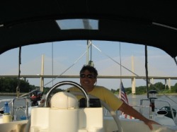
Passing under the C&D Canal Bridge
Magothy River to Cape May, NJ
Tuesday (July 24) was a much better day to travel north. The southeast wind was light, so we got little help from our sails as we made our way up the eastern arm of the Chesapeake to the Bohemia River. We anchored right in its mouth, which was just an hour and a half (current-permitting) away from Chesapeake City on the Chesapeake and Delaware (C&D) Canal.
The C&D Canal connects the northern Chesapeake Bay to the northern Delaware Bay, which provides the outlet to the Atlantic. This was going to be the first of several arteries where the current’s strength and direction needed to be seriously considered in planning our departure times and dates. We had begun researching this back in Annapolis and were told that we needed either a current copy of Reed’s (ours was from 2005) or Eldridge’s. We chose the latter, since it was significantly cheaper and came recommended by the clerk at Fawcett’s. It took a day of studying the various tables to piece together the information we needed to plan the trip through the canal and down the Delaware Bay under favorable current.
We left the anchorage by 5:30am Wednesday (July 25) and rode favorable current the entire length of the canal and much of the length of the Delaware Bay. According to Eldridge’s, we had expected the current in the canal to turn against us shortly after leaving Chesapeake City at 7am. This didn’t turn out to be the case, which was a happy surprise. We made good enough time, and the weather forecast favored Thursday over Friday for a run up the coast, so we decided that if the forecast held as we got to Cape May, we would keep going to Sandy Hook.
One other concern in the C&D Canal is that very large ships use this route to and from Baltimore. By monitoring channel 13 and our AIS, we stayed aware of what large ships were in the canal with us. There was only one that we would need to pass and nothing overtaking us. By 9am, we were in the Delaware Bay, making our way south for Cape May.
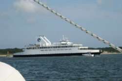
Lewes - Cape May Ferry
One of the frustrating things about traveling this route is the need to “backtrack”, heading many miles south on the Delaware Bay before turning north again in the ocean. However, we discovered that we had the right dimensions to transit the Cape May canal which cuts across the northern peninsula that defines the Delaware’s mouth. There are 2 fixed bridges with heights of 55 feet, which we should easily pass under, since we are under 50ft to the top of the antenna. This would allow us to cut 10 miles off the trip. As always happens with these things, we would be entering the canal at high tide. This made us less concerned about the channel depth, but nervous about the bridges. If the heights were less than advertised, we would be in trouble. As Dave drove, Cathy kept scouring the base of the bridge with the binoculars to find the height indicator. Much too close to the bridge, she found it and was able to confirm a 54’ height. The 2nd bridge was easier to read, and we made a smooth transit out into the Cape May harbor by 6pm. (We had to dodge the ferry and a dredge upon entering the canal, but that’s all in a day’s work these days.)
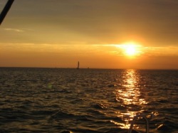
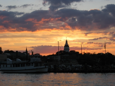
Sunset over ocean leaving Cape May
On to Sandy Hook
As we checked the weather forecast before heading out from Cape May, it remained unchanged from the morning, so we headed out the inlet and turned north. This trip differed from our past ocean excursions because we traveled so close to the coast. We could easily make out the many familiar New Jersey cities, starting with Wildwood and its amusement parks just north of Cape May. Later, the lights of Ocean City’s amusement park and Atlantic City’s casinos lit up the night, making it clear where we were. However, by traveling so close to the coast, there were some unexpected obstacles. Cathy found the lights of the aircraft approaching the Atlantic City airport confusing, and the near misses with several fishing floats required a sharp lookout. Those aren’t going to show up on AIS. Most other big ships did however, and the system provided valuable information to decipher the various lights on the water. Smaller fishing boats and sport boats entering and exiting the busy inlets were easily identified and avoided by monitoring their approach.
We made it to daylight and the approach to the entrance to the NY harbor was surprisingly quiet, since the bigger ships were traveling farther offshore. It looked like it would be an uneventful end to the trip, until around 9:30am when fog closed in. We had heard about the fog up north, but we thought we’d have some time to adjust before dealing with it. We began sounding our horn, and watching the limited horizon to find any obstacles as early as possible. The fog lifted somewhat as we made the turn up the Sandy Hook channel, but we couldn’t relax yet. Apparently, up here, fishing boats don’t think twice about floating around in the channel as they search for their catch. So, we were greeted by hundreds of fisherman on a hundred large and small boats that we kept trying to dodge as we wearily made our way around Sandy Hook to our anchorage. It was with relief that we dropped the anchor around 1pm, and promptly went to sleep. It had been a long day.
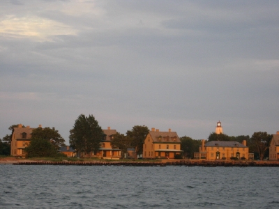
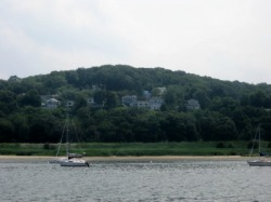
Atlantic Highlands from the mooring field
After a false start north out of Sandy Hook Bay toward NYC, we turned back and settled on an Atlantic Highlands Yacht Club mooring on Friday afternoon (July 27). The threat of thunderstorms, the late start (about 1pm) to take advantage of the currents and the uncertainty that we would find an open mooring ball at the W. 79th Street Marina on the Hudson River caused us to regroup and make a new plan. Our first trip to the dock on the launch introduced us to 2 of the yacht club members who graciously offered information about the town and encouraged us to stop up in the bar to talk to Yacht Club members there about what to see in Long Island sound. We were even given a ride to the nearby grocery store.
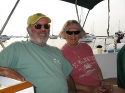
Joel and Harley Braverman
Sure enough, we were quickly greeted in the bar and had a long conversation with several members, including Joel and Harley Braverman, from Olive Aye. They had lots of ideas for our trip through NYC and Long Island sound, so we agreed to join them on Olive Aye the next day to pick their brain some more. They helped us sort through the mounds of information, some of it conflicting, about how to transit the East River and Hell Gate in NYC. Then we took notes on many ports of call on both shores of the Long Island sound, from City Island to Block Island. We left full of information that we spent the next 2 days turning into routes and an overall travel plan.
With their help, we confirmed that the earliest we could transit Hell Gate with favorable current and weather would be Tuesday (July 31). In the meantime, we took time to do laundry, see the town and visit with our neighbors, hosting both the Bravermans and our neighbors, the Lewises on Restless, who were just beginning their time living aboard.
With their help, we confirmed that the earliest we could transit Hell Gate with favorable current and weather would be Tuesday (July 31). In the meantime, we took time to do laundry, see the town and visit with our neighbors, hosting both the Bravermans and our neighbors, the Lewises on Restless, who were just beginning their time living aboard.

Sunrise over Coney Island
To Hell (Gate) and Back
On Tuesday, we were up before dawn at 4am, trying to leave as early as possible. Even with this early start, we would be heading through Hell Gate, the point of the fast current as the East River turns east toward Long Island sound, at the time of the maximum favorable current. This would mean an incredibly fast transit, since the current would add 4 knots to our speed. It would also mean standing waves, whirlpools and eddies in the faster current, while trying to stay out of the way of barges traveling the narrow East River. Needless to say, Dave took the helm for this stretch.
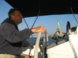
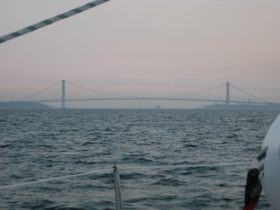
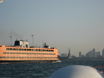
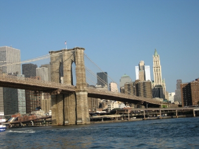
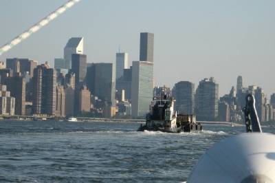
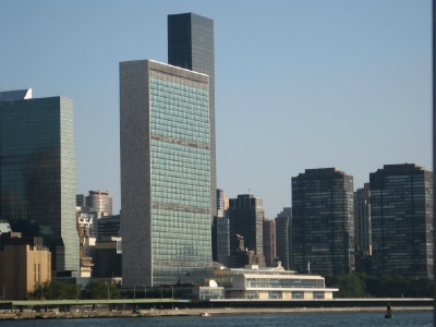
We had a beautiful day to pass the city, which made for an incredible view of many famous landmarks – the Verrazano Narrows bridge, the Staten Island Ferry, the Statue of Liberty, Ellis Island, Manhattan, the UN, and much more. I guess we got a little too close to the UN for the comfort of the Coast Guard who charged up to us, telling us to maintain our course and speed while they escorted us past the landmark. Unfortunately, we were being overtaken by a large ship behind us at the same time. They wanted us to change course (understandably) to get out of their way. As we glanced at the Coast Guard beside us and the ship behind us, the ship won. We headed to starboard, away from the UN and the ship and Coast Guard soon left us to pursue some other poor boat. The ship’s captain actually waved to us on the deck of his bridge and thanked us. Amazing! Hell Gate lived up to expectations, but without other traffic in the area, we passed it without incident and were into Long Island sound by 9am. We were on a town mooring in the Port Washington harbor by 10:30am. It had already been an unforgettable day.
On Tuesday, we were up before dawn at 4am, trying to leave as early as possible. Even with this early start, we would be heading through Hell Gate, the point of the fast current as the East River turns east toward Long Island sound, at the time of the maximum favorable current. This would mean an incredibly fast transit, since the current would add 4 knots to our speed. It would also mean standing waves, whirlpools and eddies in the faster current, while trying to stay out of the way of barges traveling the narrow East River. Needless to say, Dave took the helm for this stretch.
We had a beautiful day to pass the city, which made for an incredible view of many famous landmarks – the Verrazano Narrows bridge, the Staten Island Ferry, the Statue of Liberty, Ellis Island, Manhattan, the UN, and much more. I guess we got a little too close to the UN for the comfort of the Coast Guard who charged up to us, telling us to maintain our course and speed while they escorted us past the landmark. Unfortunately, we were being overtaken by a large ship behind us at the same time. They wanted us to change course (understandably) to get out of their way. As we glanced at the Coast Guard beside us and the ship behind us, the ship won. We headed to starboard, away from the UN and the ship and Coast Guard soon left us to pursue some other poor boat. The ship’s captain actually waved to us on the deck of his bridge and thanked us. Amazing! Hell Gate lived up to expectations, but without other traffic in the area, we passed it without incident and were into Long Island sound by 9am. We were on a town mooring in the Port Washington harbor by 10:30am. It had already been an unforgettable day.

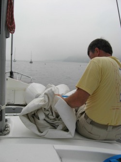
Dave bundles up our headsail to take in for repair
What about the boat?
We managed to squeeze in a few boat projects despite all the travel.
While in Atlantic Highlands, Cathy noticed some threads flying off the headsail about two-thirds of the way up. This didn’t look good. We dropped the sail the next morning and discovered the cover was coming unstitched on a 3 foot section. While the sail was fine, we weren’t going to feel good using the sail if the cover was likely to unravel. Since it was Sunday, we weren’t sure what we would do. Cathy made an effort to sew it by hand, but it was obvious that this would take days to finish. To our surprise, we were once again assisted by the gracious Atlantic Highlands boaters. The launch operator pointed us to someone on the dock who worked at a canvas shop, which was open on Sundays. She called her boss and he agreed to take a look at the sail and help us out if he could. The Bravermans graciously offered to take us to the shop to drop of the sail. By early afternoon, the sail was in the hands of Jean’s Canvas Shop with a promise to deliver it the next day. Before 3pm on Monday, we received a call that the sail was ready. We picked it up and had it back up ready for our Tuesday departure before 5. We have been the recipients of some over-the-top hospitality in this town, which we won’t forget.
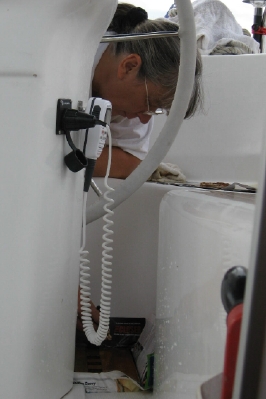
While in the Magothy River, we discovered a couple of smaller items which we had forgotten in our Cetol application in Hampton. The cockpit drain cover and the swim ladder stairs needed to be refreshed. Cathy took advantage of the time waiting for weather to apply a coat of Cetol, while Dave did a more thorough cleaning of that #@!!#& power cord, which he had only been able to clean partially in Hampton.
We managed to squeeze in a few boat projects despite all the travel.
While in Atlantic Highlands, Cathy noticed some threads flying off the headsail about two-thirds of the way up. This didn’t look good. We dropped the sail the next morning and discovered the cover was coming unstitched on a 3 foot section. While the sail was fine, we weren’t going to feel good using the sail if the cover was likely to unravel. Since it was Sunday, we weren’t sure what we would do. Cathy made an effort to sew it by hand, but it was obvious that this would take days to finish. To our surprise, we were once again assisted by the gracious Atlantic Highlands boaters. The launch operator pointed us to someone on the dock who worked at a canvas shop, which was open on Sundays. She called her boss and he agreed to take a look at the sail and help us out if he could. The Bravermans graciously offered to take us to the shop to drop of the sail. By early afternoon, the sail was in the hands of Jean’s Canvas Shop with a promise to deliver it the next day. Before 3pm on Monday, we received a call that the sail was ready. We picked it up and had it back up ready for our Tuesday departure before 5. We have been the recipients of some over-the-top hospitality in this town, which we won’t forget.
While in the Magothy River, we discovered a couple of smaller items which we had forgotten in our Cetol application in Hampton. The cockpit drain cover and the swim ladder stairs needed to be refreshed. Cathy took advantage of the time waiting for weather to apply a coat of Cetol, while Dave did a more thorough cleaning of that #@!!#& power cord, which he had only been able to clean partially in Hampton.

While in Atlantic Highlands, we decided to clean out the four water pump filters, some of which were pretty long overdue for a cleaning.
The only other item that needed some repair caught us by surprise. Our reliable, but aging, Kodak digital camera broke on the way from Solomons to Annapolis. In an amazingly fast shopping run, we spent a few hours shopping and buying another camera while in Annapolis. We couldn’t imagine passing the Statue of Liberty by boat and not being able to record the event.
The ham radio continues to work well and Dave has been trying it out frequently, expanding his contacts throughout the US and including other countries, such as Belgium, Austria, Columbia, and Italy.
Long Island Sound
We plan to spend about a week in Long Island sound, visiting some of the ports the Bravermans recommended and then we’ll head further north. Surely there will be less to talk about next time. . .
