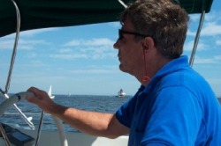
Dave steers as we pass the familiar Thomas Point Light.
In our last update, we had just celebrated the arrival of a new grandson, whom we got to visit shortly thereafter. In this most recent 2 weeks we celebrated our daughter’s wedding, and got to see our son’s family again (for a little bit longer this time). We even managed to get some sailing in between family visits.
Gadgets and Gizmos
With no engine problems to worry about, David had to look for other boat projects to work on. Most of these involve our plans for the fall, to travel down the Intra-Coastal Waterway (ICW) to Florida.
At points along the ICW, the tidal range is as much as 9 feet. Since we only experience 1-2 feet in the Bay, this dramatically affects the length of the dock lines needed to accommodate this tidal range. We didn’t have any that were long enough. The recommendation is that you have lines equal to one and a half of your boat length. This meant we needed lines 55 feet or longer. (Not to take anything at face value, we actually used some algebra to verify this calculation. Yes, kids. You will use this after you leave school.) Since the cost of lines this long at the local West Marine store would be pretty high, David returned to his favorite shopping location, e-Bay, to find the necessary lines. Although he didn’t find exactly what he wanted there (combination of 5/8” diameter and 55 feet length), he identified a seller who had a lot of variety of rope lengths for sale. He contacted him directly for our specific requirements and was able to purchase the 4 lines at a bargain price.
Another difference between sailing the bay, and traveling the ICW is the fact that we have charts – both paper and electronic – for the bay, and we have none for the ICW. Since we rely so heavily on our Garmin 172C chartplotter to navigate the bay with the detailed electronic charts that we purchased for it that encompass the Bay, we knew we needed to have similar charts for the coast down to Florida. We have also been sensitive to the fact that we don’t currently have a good backup for this chartplotter that we use so much. While we have the charts, waypoints and routes loaded on our PC, along with Garmin’s software that allows us to create routes on the PC, we don’t currently have a way to display our position on these charts on the PC. So, the PC can serve as a backup for the data in the Garmin unit, but not to the real-time navigation. This is a critical component to an effective backup. To do this using our existing software, we would need another Garmin remote GPS unit, which we don’t have. David purchased a less expensive remote GPS that interfaces with the computer, which has given us a limited solution. Garmin has restricted its software to prevent non-Garmin units from displaying position on the detailed charts within its software. It will allow the position data to display on a generic chart that has very general features on it (for example, when in our slip at Liberty Marina on the South River, it shows us as sitting on land) and on the route line that we’ve plotted.
Another wrinkle in our pursuit of electronic charts is that, within the past year, NOAA released free downloadable versions of all of its charts– both simple scanned images of existing charts (called raster charts) and more complex encoded data (called vector or electronic charts). It would be nice to be able to take advantage of all of those free charts, but finding the necessary software becomes the problem.
So, our requirements boil down to the following: 1) expand our charts to include the ICW and Bahamas on a chartplotter at the helm, 2) provide a backup for the helm chartplotter, and 3) get the most up-to-date charts. After a bit of research, we narrowed our choices down to the following that made the most sense for us.
To get the latest charts at the helm, only 2 options make sense for us:
For the PC backup, we are leaning toward option 1, purchasing a PC software package to use the NOAA charts and our remote GPS. The risk of hooking up another Garmin GPS to our existing charts is that Garmin only allows 2 GPS units to access the charts. If we hooked up 2 units and either failed, we would immediately lose our backup and would have to purchase new charts to activate a new replacement GPS. Pretty expensive.
Gadgets and Gizmos
With no engine problems to worry about, David had to look for other boat projects to work on. Most of these involve our plans for the fall, to travel down the Intra-Coastal Waterway (ICW) to Florida.
At points along the ICW, the tidal range is as much as 9 feet. Since we only experience 1-2 feet in the Bay, this dramatically affects the length of the dock lines needed to accommodate this tidal range. We didn’t have any that were long enough. The recommendation is that you have lines equal to one and a half of your boat length. This meant we needed lines 55 feet or longer. (Not to take anything at face value, we actually used some algebra to verify this calculation. Yes, kids. You will use this after you leave school.) Since the cost of lines this long at the local West Marine store would be pretty high, David returned to his favorite shopping location, e-Bay, to find the necessary lines. Although he didn’t find exactly what he wanted there (combination of 5/8” diameter and 55 feet length), he identified a seller who had a lot of variety of rope lengths for sale. He contacted him directly for our specific requirements and was able to purchase the 4 lines at a bargain price.
Another difference between sailing the bay, and traveling the ICW is the fact that we have charts – both paper and electronic – for the bay, and we have none for the ICW. Since we rely so heavily on our Garmin 172C chartplotter to navigate the bay with the detailed electronic charts that we purchased for it that encompass the Bay, we knew we needed to have similar charts for the coast down to Florida. We have also been sensitive to the fact that we don’t currently have a good backup for this chartplotter that we use so much. While we have the charts, waypoints and routes loaded on our PC, along with Garmin’s software that allows us to create routes on the PC, we don’t currently have a way to display our position on these charts on the PC. So, the PC can serve as a backup for the data in the Garmin unit, but not to the real-time navigation. This is a critical component to an effective backup. To do this using our existing software, we would need another Garmin remote GPS unit, which we don’t have. David purchased a less expensive remote GPS that interfaces with the computer, which has given us a limited solution. Garmin has restricted its software to prevent non-Garmin units from displaying position on the detailed charts within its software. It will allow the position data to display on a generic chart that has very general features on it (for example, when in our slip at Liberty Marina on the South River, it shows us as sitting on land) and on the route line that we’ve plotted.
Another wrinkle in our pursuit of electronic charts is that, within the past year, NOAA released free downloadable versions of all of its charts– both simple scanned images of existing charts (called raster charts) and more complex encoded data (called vector or electronic charts). It would be nice to be able to take advantage of all of those free charts, but finding the necessary software becomes the problem.
So, our requirements boil down to the following: 1) expand our charts to include the ICW and Bahamas on a chartplotter at the helm, 2) provide a backup for the helm chartplotter, and 3) get the most up-to-date charts. After a bit of research, we narrowed our choices down to the following that made the most sense for us.
To get the latest charts at the helm, only 2 options make sense for us:
- Upgrade to a newer Garmin chartplotter (model 492) that comes with the charts already loaded.
- Keep our existing Garmin unit, but buy the most current charts for the ICW and Bahamas and upgrade our existing charts to the latest release.
- Find an inexpensive PC software package that would take advantage of the free NOAA charts and our remote GPS unit.
- Buy the Garmin remote GPS unit for use with our existing software.
For the PC backup, we are leaning toward option 1, purchasing a PC software package to use the NOAA charts and our remote GPS. The risk of hooking up another Garmin GPS to our existing charts is that Garmin only allows 2 GPS units to access the charts. If we hooked up 2 units and either failed, we would immediately lose our backup and would have to purchase new charts to activate a new replacement GPS. Pretty expensive.

Domino Sugar plant in the Inner Harbor
North to Baltimore
Well the confederates made it as far north as Gettysburg, but, so far, Baltimore is our most northerly port. We arrived there on Monday, July 31st and promptly left for 2 days. This was actually a good decision, since this was the week of the intense heat wave rolling across the east coast. So, we managed to avoid 2 days of the 4 day heat wave.. When we returned, we had our air conditioning on board, and we managed to enjoy the amenities of the Harborview marina, which was very nice. Floating docks, attentive deck hands (that met us every time we pulled back in), a “floating” pool in the harbor, an Ethernet internet connection, the essential on-site laundry and very helpful office staff. It was also only a 5 minute walk from the Inner Harbor.
Our first stop in search of enlightenment was the Maryland Science Center on the Inner Harbor walkway. We wandered through 3 floors of hands-on exhibits, which were fun even for us old folks. (The average age was considerably younger.)

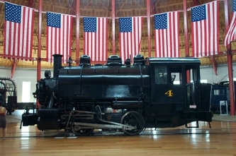
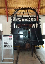
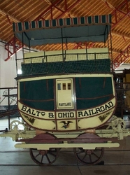
The next day we walked over to the B&O Railroad Museum. Railroading in the western hemisphere started in Baltimore, and the Baltimore and Ohio yards used to cover many more acres of downtown real estate than they do today. The museum had the largest number and some of the most unusual rail cars and engines of any museum we’d visited. The roundhouse which is still standing has been restored, with a working turntable. It suffered serious damage in the President’s Day storm of 2003, when the roof collapsed, but it has since been repaired and re-opened. The museum includes a 20 minute train ride as well.
Paragraph.
Actually, there was an “Otakon 2006” conference underway, which is somehow related to video gaming. So, we can’t attribute all of the oddly dressed pedestrians to “typical” Baltimore residents.
We tried another walking tour of the Baltimore sites to try to visit the Shot Tower, north of Inner Harbor. (This is a place where they used to pour molten lead down from the top to make gun shot of various sizes.) Unfortunately, when we got there, it was closed due to excessive heat (tell me about it!), so we consoled ourselves with some delicious sweets from an excellent nearby bakery.
Friday night at the Inner Harbor was lively, with a live concert by a jazz band and other street performers along the walkway. We grabbed something to eat and sat on the balcony of Harborplace while we ate, enjoying the music and the activity.

Friends and Family
For much of the past few weeks, the light summer winds and their direction have prevented us from sailing very much. We’ve had to motor almost everywhere. However, we were finally able to put the sails up again when we took a sail down the Patapsco River in Baltimore. We were joined there by Tracy, one of David’s former co-workers, and his family. We took a spin in the Inner Harbor and then out into the Patapsco where the winds were up. We also had a nice sail from Annapolis (where we went after Baltimore) almost all the way up the South River, as we were moving the boat to Liberty for a week while we went off to the wedding.
And as for the wedding, it was a beautiful occasion. Bonnie and Troy had planned a special event to begin their life together. Many tears (of joy, of course) were shed before it was all over. We were thrilled to be there and be a part of it.
Bored yet?
We are frequently greeted with questions regarding our life on board Orion.
Is it wonderful, exciting, relaxing, fun, a great adventure? OR
Is it cramped, hot, too close for comfort, a lot of work, just plain boring?
The answer to all those questions is . . . yes. At times, each of those aspects is a reality of our life on board. We’ve had opportunities to do things, meet people and learn about ourselves in ways we haven’t had before. It’s also true that part of every life is the routine things that still need doing: shopping, cooking, cleaning, maintenance, etc. You just have to do them in less space and with more concern about how economically you’re using your resources. But that’s OK. It’s just part of the rhythm of life on a boat, and it means that we haven’t decided to pack it in just yet. We have a bit further to go before we’ll close this chapter of our lives.
